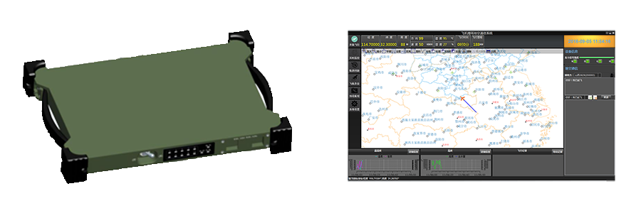
We have developed a new type of airborne equipment, which integrated Beidou satellite system, global positioning system, electronic map and application software to suitable for the development of weather service.
1. Positioning: BeiDou, GPS, GLONASS.
2. Multi antenna: Supportting side exit and lower exit antenna.
3. Communication:Supportting BeiDou Navigation Satellite System Short Messages(BeiDou-SMS),Short message (SMS) can be sent to the specified user.
4. Collection:Acquisition and storage data of GPS, airborne detection equipment.
5. Display: Real-time display of time, longitude, latitude, altitude, speed, heading, temperature, humidity and other information with the graph.
6. GIS function: Supportting the electronic map display, zoom in, zoom out, panning, ranging, measuring area, screenshots,etc.
7. Mapping function: Supportting adding points, line, face operation manually on the map.
8. Display meteorological information: Supportting overlay radar, MiCAPS cloud on the map.
9. Air route design: Route planning for artificial weather operations and generate documents, sent to the aircraft for display through BeiDou-SMS.
10. Track playback: Playback of weather operations flight’s trajectory files and show all the information recorded during flight.
11. Information recording: Manually record macro weather situation, automaticly record time, location and the amount of catalyst data of the seeding.
12. Information setting: Set up the type, manufacturer, model and other information of the airborne catalyst; set up the working personnel, landing airport, aircraft number, operation type and other information.
13. Automatic transmission of data: Automatic transmission of data for flight time, longitude, latitude, altitude, speed, heading, temperature, humidity and other information through the BeiDou-SMS to the ground command center.
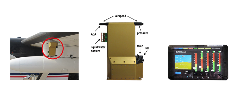
CWIP是專門(mén)爲飛機(jī)人(rén)工(gōng)增雨(yǔ)催化作(zuò)業設計(jì)的機(jī)載探測系統。CWIP以雲催化爲目的,爲登機(jī)作(zuò)業人(rén)員(yuán)實時提供雲的信息。CWIP能夠采集大(dà)氣環境信息,包括:溫度、相(xiàng)對濕度、液态含水量、垂直速度和高空風(fēng)向風(fēng)速。飛機(jī)觀測到的這些氣象數據可(kě)以用作(zuò)雲催化的判定指标,協助作(zuò)業人(rén)員(yuán)找到适合催化的作(zuò)業部位。當進行飛機(jī)人(rén)工(gōng)增雨(yǔ)作(zuò)業飛行時,CWIP隻利用一台儀器采集所有需要的數據,并通過計(jì)算爲登機(jī)作(zuò)業人(rén)員(yuán)提供可(kě)參考的“催化分(fēn)數”。登機(jī)作(zuò)業人(rén)員(yuán)根據各項指标的“催化分(fēn)數”,找到适合催化作(zuò)業的雲的部位進行作(zuò)業,從(cóng)而達到科(kē)學化人(rén)工(gōng)增雨(yǔ)的目的。
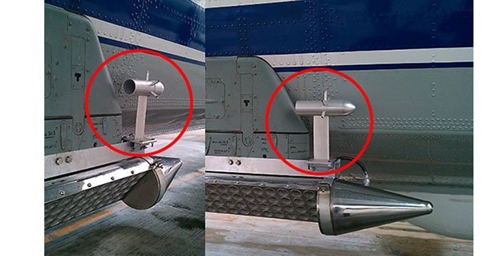
慣性導航系統可(kě)以提供飛機(jī)的加速度,速率,位置和姿态,一般安裝在飛機(jī)機(jī)艙的頂部,CWIP空氣傳感器探頭用于觀測飛機(jī)迎角,空速管壓力,靜(jìng)壓,溫度,相(xiàng)對濕度和液态含水量,一般安裝在飛機(jī)的機(jī)翼下方或者機(jī)頭位置。CWIP能夠采集大(dà)氣環境信息,包括:溫度、相(xiàng)對濕度、液态含水量、垂直速度和高空風(fēng)向風(fēng)速。
1.可(kě)以幫助實施飛機(jī)增雨(yǔ)的登機(jī)作(zuò)業人(rén)員(yuán)找到雲的合适催化部位。
2.設備可(kě)在人(rén)工(gōng)增雨(yǔ)飛機(jī)上簡單安裝。
3.爲實施飛機(jī)增雨(yǔ)的登機(jī)作(zuò)業人(rén)員(yuán)集中顯示溫度、濕度、高度、空速、上升氣流速度、迎角和液體(tǐ)含水量的數據。
4.采用電子飛行儀表系統(Electronic Flight Instrument System,簡稱EFIS)顯示風(fēng)格(飛機(jī)駕駛艙顯示飛行信息的電子顯示系統顯示風(fēng)格)。
5.可(kě)使用默認或用戶自(zì)定義的雲底和雲頂催化播種算法。
6.當催化條件(jiàn)符合時,給登機(jī)作(zuò)業人(rén)員(yuán)提示。
7.可(kě)幫助登記作(zuò)業人(rén)員(yuán)進行前一催化部位的導航。
8.支持北鬥衛星或其它傳輸系統下傳探測數據。
環境溫度、相(xiàng)對濕度、大(dà)氣壓力、雲液态含水量、真實空速、迎角、GPS緯度、經度、GPS海拔、GPS地速,GPS軌迹、X,Y和Z軸的速度和加速度、磁航向,真航向、轉彎速度,偏航角,俯仰角,橫滾角、風(fēng)速和風(fēng)向、空氣垂直速度
CWIP有6部分(fēn)組成,包括:(1)Fin探頭,(2)AHRS模塊,(3)GPS模塊,(4)ADC模塊,(5)Linux數據系統,(6)iPad平闆顯示系統。這6個組成部分(fēn)組合到一起實時提供我們所需要的探測數據。
Beidou satellite navigation system is a global satellite positioning and communication system (BDS) developed by China, which is the third mature satellite navigation system after the global positioning system (GPS) and the Russian GLONASS.
系統由空間端、地面端和用戶端組成,可(kě)在全球範圍内全天候、全天時爲各類用戶提供高精度、高可(kě)靠定位、導航、授時服務,并具短(duǎn)報文通信能力,已經初步具備區域導航、定位和授時能力
北鬥系統實施“三步走”發展戰略:第一步,2000年(nián)建成了北鬥衛星導航試驗系統解決我國(guó)自(zì)主衛星導航系統的有無問(wèn)題;第二步,建設北鬥衛星導航系統,2012年(nián)形成區域覆蓋能力;第三步,2020年(nián)左右,形成全球覆蓋能力。
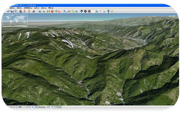
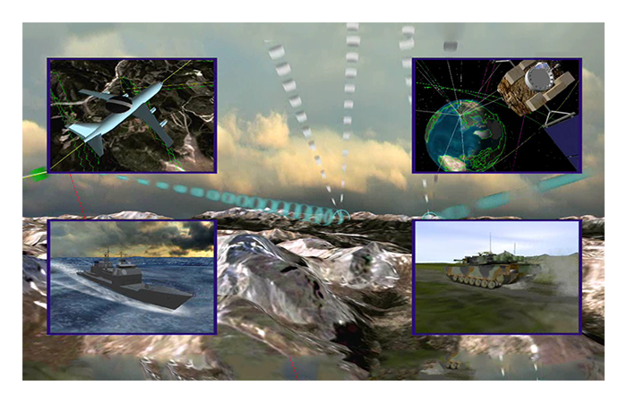
系統基于 OpenGL 标準,綜合采用3S技術(shù)、海量數據管理(lǐ)技術(shù)、圖形圖像集成技術(shù)、地理(lǐ)空間數據與非空間信息綜合管理(lǐ)等技術(shù), 利用C++語言開發,雲航科(kē)技具有自(zì)主知識産權的應用軟件(jiàn)系統。系統具有情報綜合可(kě)視化能力和強大(dà)的電子沙盤能力,能夠實現宏觀與微觀尺度空間信息的一體(tǐ)化表達、仿真與推演等功能。系統不僅支持 Windows 操作(zuò)系統,還(hái)支持 Linux 和 Unix 系統,具有跨平台特點。
三維電子沙盤系統是以基礎地理(lǐ)信息數據、模型數據、屬性數據、圖形數據爲數據基礎,以各種三維仿真的手段建立的系統,數據是整個系統的基礎。基礎地理(lǐ)空間信息數據庫包括主比例尺的地形圖(DLG)、正射影(yǐng)像圖(DOM)、栅格圖數據(DRG)、數字高程模型(DEM)數據等戰場基礎地理(lǐ)空間數據。
(一)、地形信息準确:采用國(guó)家标準地形圖建立數字地面模型,可(kě)以準确的按比例還(hái)原地貌形态;
(二)、地物表示詳細:采用衛星遙感影(yǐng)象做爲地表貼面,反映和實地一樣的地表形态,河流、植被、道路(lù)、居民(mín)地等信息一目了然。
(三)、地物表現直觀:衛星遙感影(yǐng)象的色彩,經過合理(lǐ)的波段組合和時相(xiàng)選取,可(kě)以模拟實地景觀,如(rú)同身(shēn)臨其境。
(四)、浏覽方便:在三維電子沙盤中進行任意縮放(fàng)和漫遊、可(kě)以模拟飛行,對目标進行全方位的觀察分(fēn)析;
(五)、地形信息檢索:可(kě)以查詢任意某地的地理(lǐ)坐(zuò)标和海拔高度;
(六)、地形分(fēn)析和量算:可(kě)以在上面進行距離(lí)、面積、體(tǐ)積的量算,還(hái)可(kě)以進行通視、剖面、淹沒等分(fēn)析;
(七)、模拟:可(kě)以在上面任意位置模拟火(huǒ)場、爆炸等,并進行路(lù)線選擇和規劃;
(八)、将地面設施立體(tǐ)化:将樓房(fáng)等基礎設施等,以三維方式展現;
(九)、屬性查詢:可(kě)以直接在三維電子沙盤上查詢各種信息;
(十)、集成GPS、北鬥系統:實現直接在三維電子沙盤上跟蹤和調度。

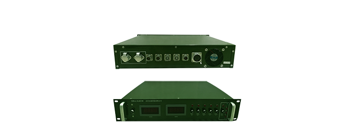
Airborne Power Management System effectively support for the power supply and management of all products of the airborne equipment to enhance the security of the aircraft in flight.
DC Input:DC:21-40V
Maximum Power:1400W
DC Output:DC:24V*1 , DC:28V*4
AC Output:AC: 220V*2
Power:450W
Output Overload Protection: When load power is more than 120%, after 60s, it will turn off the output.
Type:YH-HT02
Power Voltage:DC5V
Power Waste:4mA
Measuring Range:Humidity:0…100%RH / Temperature:-40…85℃
Accuracy (23℃):Humidity±1.5%RH/ Temperature:±0.3℃
ROV Output:Humidity:0…100%RH = 0…1V / Temperature:-40…85℃ = -0.4…0.85V
Digital Output:Single bus digital input / output DIO
Start-up Time:Start-up in 2.7s; 0.7s to update data for Continuous measurement
Resolution:Humidity:100%RH / Analog output 12 bit, digital output of 16 bit
Temperature:250℃ / Analog output 12 bit, digital output of 16 bit
Repeatability:Humidity:<0.5%RH / Temperature:<0.1℃
Sensor:Humidity:Hygromer AC-1/ Temperature:Pt100 1/3DIN
Sensor Protection:PTFE filter
Protection Level:IP65
Cable Length:30m

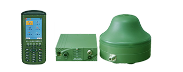
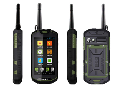
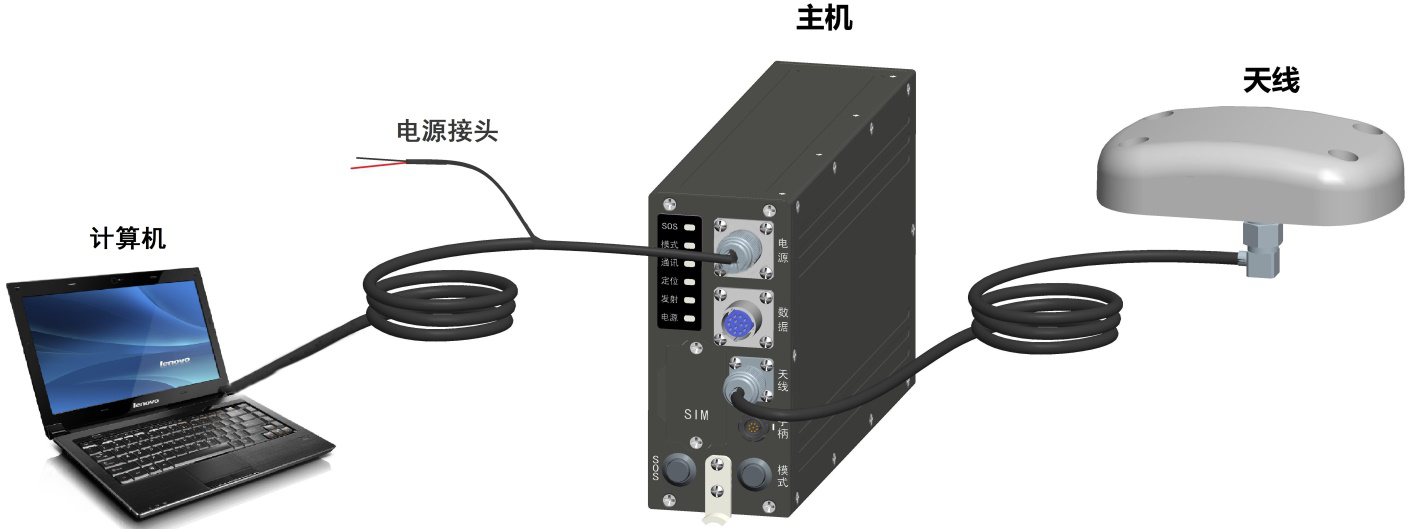
Aviatic Beidou User Terminal supports RNSS and RDSS and has Beidou-SMS communication function. The user terminal can be connected with the Beidou ground command network to form a command and control system. The ground command center can monitor and control the real time position of the aircraft by using the command and control system.
1. Supportting BD B1 B3, GPS L1 positioning for real-time navigation and positioning.
2. RNSS system integrity information processing and receiver autonomous integrity monitoring (RAIM) and alarm.
3. Support RDSS positioning, SMS, position reporting.
4. Human-computer interaction control and navigation parameters display.
5. Power management. The power supply has the function of automatic protection when it is over current, over voltage, under voltage, or occasionally polarity.
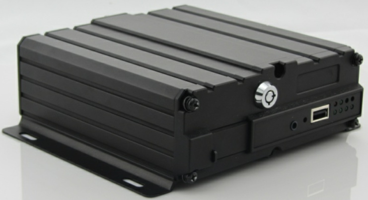
人(rén)工(gōng)影(yǐng)響天氣地面作(zuò)業實景監控系統主要實現指揮中心對各作(zuò)業點現場的實時視頻監控和語音對講。視頻監控,語音對講技術(shù)可(kě)有效的爲人(rén)影(yǐng)工(gōng)作(zuò)提供強大(dà)的技術(shù)支撐,可(kě)通過有線寬帶、4G無線等多種通信方式實時記錄高炮、火(huǒ)箭的作(zuò)業過程,從(cóng)而有效的監督作(zuò)業的規範性,有安全事(shì)故發生(shēng)時有據可(kě)查。

4路(lù)AHD/IPC視頻輸入
雙向語音對講
音視頻本地硬盤存儲
4GLTE雙卡綁定傳輸
支持WIFI或有線網絡連接
CVBS/VGA本地視頻回顯
GNSS北鬥/GPS定位